Introduction to Conservation Management Plans (CMPs) for Northern Ireland’s Special Areas of Conservation
Northern Ireland is home to iconic and important nature and wildlife, of both national and international importance, which are a key part of the Northern Ireland landscape, providing a wide range of goods and services to society and helping to deal with climate change.

Some of our key areas for nature conservation have been designated as Special Areas of Conservation, or SAC for short. These are designated to protect special habitats or species of international importance, as listed in The Conservation (Natural Habitats, etc.) Regulations (Northern Ireland) 1995 (as amended), to ensure ‘the conservation of a wide range of rare, threatened or endemic animal and plant species. Some 200 rare and characteristic habitat types are also targeted for conservation in their own right.’ All of the SAC sites chosen under The Conservation (Natural Habitats, etc.) Regulations (Northern Ireland) 1995 (as amended) are collectively known as the UK national site network which is a network of protected areas across the EU, which forms part of a wider international Emerald Network of Areas of Special Conservation Interest. The sites are chosen according to scientific criteria to ensure favourable conservation status of each habitat type and species. Favourable conservation status means managing the site to ensure the special habitats and species are healthy.
Northern Ireland has 58 areas that have been designated as SACs covering terrestrial, freshwater and marine habitats. Some of these are cross-border sites.
The habitats and species that occur in our SACs are called ‘features’ and they are of international importance. These SACs are vitally important as their purpose is to protect Northern Ireland’s biodiversity.
Important features of Northern Ireland’s SACs include freshwater pearl mussel, grey seal, bogs, otters, salmon, sand dunes, rivers and lakes, estuaries, heaths, mountains and woodland.
For a list of our SACs and their important features, please visit Protected areas search.
Unfortunately many of our SACs are not in good health. The reasons for this include climate change, inappropriate land management, water and air pollution, invasive non-native species and development. To help bring our SACs back into good condition, we need to establish key measures to address these pressures. With that in mind, we are preparing individual Conservation Management Plans for 57 of our SACs. These plans help figure out what is wrong in each SAC and propose ways of fixing the problems. Fixing the problem could be as simple as getting the site grazed more or blocking drains on a bog to make it wetter. Writing a Conservation Management Plan involves going out onto the site and looking at all the features and assessing what ‘condition’ they are in or how healthy they are and assessing any issues. Issues include things that are impacting the site and its features right now, known as pressures and things that may impact the site and its features in future, known as threats.
Stakeholder engagement is key to the success of the Conservation Management Plans. We expect the Management Plans to provide a mechanism for discussing and agreeing appropriate land use and management with land managers, farmers and other key stakeholders within the sites to develop practical measures and identify available funding sources.
It is intended that these Conservation Management Plans will meet the conservation requirements of the sites with community participation resulting in workable, sustainable plans.
For more information please email ConservationPlans@daera-ni.gov.uk

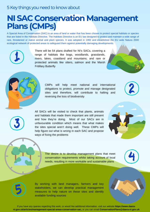
5 Key things you need to know about conservation management plans
Conservation Management Plans StoryMaps
Phase one
For the last 4 years, DAERA NIEA has been working on the development of Conservation Management Plans (CMPs).
The first phase of CMP development is complete and as of March 2024, 40 CMPs are available.
The Conservation Management Plans are published as an interactive StoryMap experience. Each SAC CMP StoryMap is a combination of interactive maps, images and informative text designed to give a clearer understanding of the SACs, their features, pressures and threats acting on the features, and the necessary conservation measures/actions required to move the features of each SAC towards favourable condition.
Visit this link to explore the first phase of SAC CMP StoryMaps
More CMPs will become available as they are completed. For more information or access to the full CMPs, please contact conservationplans@daera-ni.gov.uk